
With a total size of 52,419 square miles (135,760 km2), Alabama is the thirty-first-largest state in the country. 3.2% of that area is covered by water, placing Alabama 23rd in terms of surface water and giving it the second-largest inland canal system in the country.
22 million acres (89,000 km2), or 67%, of Alabama’s total land area are covered in forests. The state’s largest county in terms of both land area and water area is suburban Baldwin County, which is located along the Gulf Coast.
Listed below are the biggest cities in Alabama.
1. Huntsville
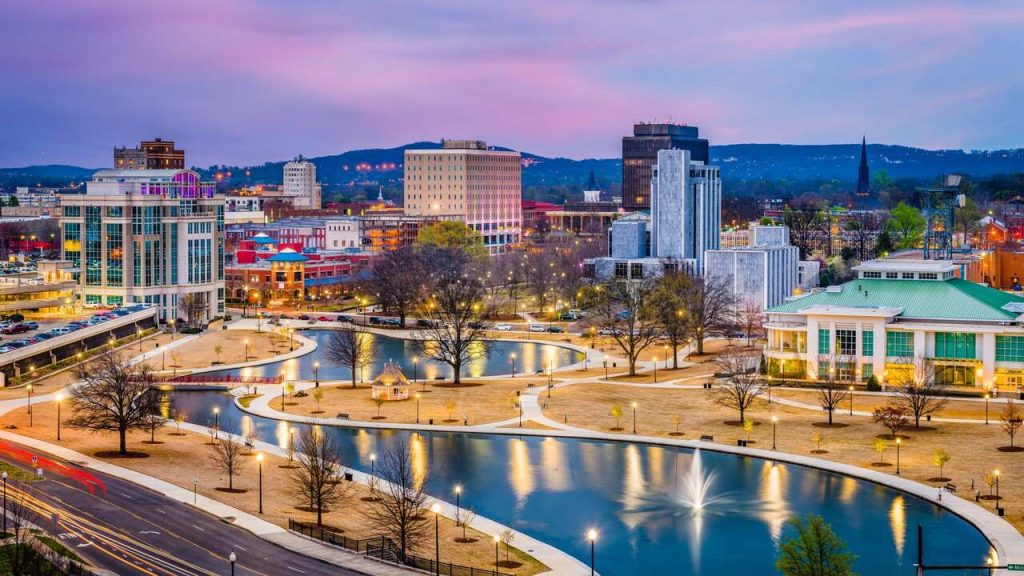
Huntsville is a city in the American state of Alabama’s Madison County. The most populated city in Alabama is Huntsville, which is situated in the Appalachian region of the north. Incorporated in 1811, Huntsville was established in the Mississippi Territory in 1805. Huntsville was first chosen as the state capital of Alabama when it was accepted as a state in 1819, but it was later transferred to a more central location.
Huntsville, which is located in the basin of the Tennessee River, is partly encircled by a number of plateaus and sizable hills. These plateaus, which are known as “mountains” locally, are connected to the Cumberland Plateau. Along with Round Top (Burritt), Chapman, Huntsville, and Green mountains, the most prominent is Monte Sano Mountain, which is also known as the “Mountain of Health” and is located east of the city.
2. Montgomery
With 199,518 inhabitants, Montgomery is the second-most populous city in Alabama. It serves as Alabama’s state capitol as well. On the banks of the Alabama River, Montgomery was created in 1819 by the union of two settlements. After Huntsville, it has the second-highest population in Alabama and ranks 119th in terms of population nationwide.
The Montgomery Metropolitan Statistical Area has a population of 386,047 in 2020, ranking it 142nd among metropolitan areas in the United States and fourth in the state. A total of 156.2 square miles (405 km2) of land and 0.8 square miles (2.1 km2) (0.52%) of water make up the city’s total area. The city is situated 220 feet (67 meters) above sea level on a sloping ground.
3. Birmingham
Birmingham, which is located in the north-central region of the state and has a population of around 210 710, is the biggest city in Alabama. Three previous agricultural communities were combined to become Birmingham in 1871, during the Reconstruction era that followed the Civil War. A total of 151.9 square miles (393 km2) of land and 2.0 square miles (5.2 km2) (1.34%) of water make up Birmingham.
Of this total area, 149.9 square miles (388 km2) is land. Birmingham’s steel industry historically contributed significantly to the city’s growth, and industry continues to be vital to the city’s economy today. The 1970s and 1980s saw investments in biotechnology and medical research reshape Birmingham’s economy.
Check out our list of the cheapest cities in Alabama.
4. Mobile
Mobile, the fourth-largest city in Alabama, has 190,265 inhabitants. The city is the sole seaport in the state and is situated on the Mobile River at the head of Mobile Bay. The county seat of Mobile County is in Mobile. The city was founded by French colonialists in 1702 and served as colonial New France’s capital until it was admitted into the United States in 1813. The French established Mobile as the first capital of Louisiana in 1702.
Mobile was a colony of France for the first 100 years of its existence, then of Great Britain, then of Spain. With the conquest of West Florida from Spain by President James Madison in 1813, Mobile became a part of the United States.
The city is a significant industrial center, especially for the steel, shipbuilding, building, medical, and aerospace sectors. 180.1 square miles (466 km2) is the total area of Mobile, with 139.5 square miles (361 km2) being land and 40.6 square miles (105.2 km2), or 22.5% of the total, being water. At the Mobile Regional Airport, the elevation is 211 feet (64 meters), compared to 10 feet (3 meters) on Water Street in the downtown area.
5. Tuscaloosa
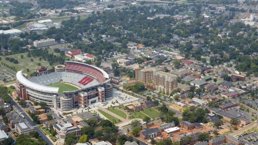
The fifth most populous city in Alabama is Tuscaloosa. The city, which has a population of about 100,287, serves as Tuscaloosa County’s county seat. It was established as a town in 1819 and is situated near the fall line of the Atlantic Coast on the banks of the Black Warrior River. 70.3 square miles (182 km2) is the total area of Tuscaloosa, of which 60.2 square miles (156 km2) are land and 10.1 square miles (26 km2) are water.
The Black Warrior River and Lake Tuscaloosa, which are located wholly within the city limits, contain the majority of the water there. The landscape of the region around Tuscaloosa is varied, ranging from heavily forested hills to the northeast to a low-lying, marshy plain to the southwest. This is due to its placement on the border between the Appalachian Highland and the Gulf Coastal Plain.
Given that Tuscaloosa is home to the University of Alabama and several colleges, higher education is currently a significant component of the city’s economy. However, the city also has strong service and manufacturing industries.
6. Hoover
Hoover is a city located in north central Alabama’s Jefferson and Shelby counties. Hoover is the sixth-biggest city in Alabama and its largest suburb. In Hoover, there are about 92,606 people. The Birmingham-Hoover, AL Metropolitan Statistical Area and the Birmingham-Hoover-Talladega, AL Combined Statistical Area both include Hoover. The region of Hoover runs alongside the Appalachian Mountains’ foothills.
Hoover, which had been known as the Green Valley neighborhood since the 1930s and was mostly a suburban area at the foothills of the Appalachian Mountains, was primarily a residential community in the late 1970s and early 1980s. William H. Hoover (1890–1979), the proprietor of a nearby insurance company, was honored with the city’s name when it was formed in 1967.
A total of 43.65 square miles (113.1 km2) of land and 0.51 square miles (1.3 km2) (1.17%) of water make up Hoover’s total area.
Take a look at the Most Populated Cities in Alabama.
7. Auburn
United States of America’s Lee County, contains the city of Auburn. With 76,143 residents, it is the biggest city in eastern Alabama. The Auburn-Opelika Metropolitan Area’s main city is there. Auburn, which houses Auburn University, is a storied college town. Auburn, which houses Auburn University, is a storied college town. Since 1990, it has experienced the nineteenth-fastest rate of growth in the nation and is the fastest-growing metropolitan region in Alabama.
The phrase “Sweet Auburn!”The Loveliest Village On The Plains,” from Oliver Goldsmith’s poem The Deserted Village, serves as the city’s unofficial moniker. The prettiest settlement in the plain. The total area of Auburn is 39.6 square miles (103 km2), of which 39.1 square miles (101 km2) are land and 0.4 square miles (1.0 km2) are water. This is 1.11% of Auburn’s total area.
Although Auburn is 709 feet (216 meters) above sea level at City Hall, its topography is varied, with elevations ranging from 386 feet (118 meters) above sea level where Chewacla Creek crosses Sand Hill Road to 845 feet (258 meters) above sea level in northern Auburn close to the Chambers County line.
8. Dothan
Dothan, the county capital of Houston County in the U.S. state of Alabama, is a city located in Dale, Henry, and Houston counties. With 71,072 inhabitants, it is the eighth-largest city in Alabama. About 20 miles (32 km) west of Georgia and 16 miles (26 km) north of Florida, it is close to the state’s southeast corner.
The main city of the Dothan, Alabama metropolitan region is Dothan; it includes the entirety of the counties of Geneva, Henry, and Houston, and a small piece of Dale County, which is a component of the Ozark Micropolitan Statistical Area. Dothan is referred to as “The Peanut Capital of the World” because a quarter of the US peanut harvest is produced locally, with a large portion of it being processed in the city.
At the Peanut Festival Fairgrounds, it also holds the annual National Peanut Festival. Dothan is located in southeast Alabama’s Houston County in the northwest. The city’s boundaries reach northwest into Dale County and north into Henry County. The city has an area of 89.7 square miles (232.4 km2), of which 89.4 square miles (231.5 km2) is land and 0.31 square miles (0.8 km2), or 0.36%, is water, according to the United States Census Bureau.
9. Madison
The majority of the city of Madison is situated in Madison County, which is close to Alabama’s northern border. West of Limestone County, where Madison borders, is another county. The city is a part of the combined Huntsville-Decatur Combined Statistical Area as well as the second-largest metropolitan area in the state, Huntsville.
The city has a population of about 56,933 people. Madison was mostly a tiny town for a long time before Redstone Arsenal was built nearby, and many people moved there in search of employment. The population of the city swiftly grew as a result, and the economy was encouraged. A total of 30.5 square miles (79.0 km2) of land and 0.1 square miles (0.3 km2), or 0.43%, of water make up Madison’s total area.
The only city larger than Madison north of the Tennessee River is its neighbor Huntsville. Residents of Madison who work at Redstone Arsenal or Research Park are many. In Alabama’s top 10, Madison has experienced some of the quickest growth and, on average, is one of the wealthiest cities.
10. Decatur
In the state of Alabama, Decatur is the biggest city. It is known as “The River City” and is situated in northern Alabama along the Tennessee River and Wheeler Lake. The population was 57,938 in 2020. The central city of the 156,494-person Decatur metropolitan area, which spans two counties, is Decatur. Decatur is the second-largest city in the Huntsville-Decatur Combined Statistical Area, which also includes the Huntsville Metropolitan Area.
A total of 60.9 square miles (158 km2) of land and 6.5 square miles (17 km2), or 10.68%, of water make up Decatur. Of this total area, 54.4 square miles (141 km2) are land. [2] Decatur is located 44 miles (71 km) east of Muscle Shoals, 25 miles (40 km) southwest of Huntsville, and 86 miles (138 km) north of Birmingham. Decatur’s early success, like that of many other southern communities in the early 19th century, was largely a result of its riverfront location.
The community was propelled to the forefront of North Alabama’s economic climate by railroad connections and boat trade. The city quickly expanded into a significant economic hub for the Tennessee Valley and served as a hub for people and goods traveling between Nashville and Mobile, Chattanooga, and New Orleans.
11. Florence
In the northwest of Alabama, in Lauderdale County, there is a city by the name of Florence. The University of North Alabama, the state’s first university, is located there beside the Tennessee River. In Florence, there are about 39,319 people. The Florence-Muscle Shoals Metropolitan Statistical Area, sometimes known as “The Shoals,” has Florence as its largest and primary city.
A total of 25.0 square miles (65 km2) of land and 0.1 square miles (0.26 km2) (0.40%) of water make up Florence’s total area. The Tennessee River’s Pickwick Dam and Wilson Dam-dammed lakes, Wilson Lake and Pickwick Lake, are where Florence is situated. The principal economic center of northwest Alabama is thought to be Florence.
12. Vestavia Hills
Vestavia Hills, also referred to as Vestavia, is a city in the U.S. state of Alabama’s Jefferson and Shelby counties. Vestavia, Liberty Park, and Cahaba Heights make up this neighborhood in Birmingham. The estimated population of Vetavia Hill is 34,033. After Birmingham and Hoover, it rose from being the fifth-largest city in Jefferson County in 2000 to becoming the third-largest in 2010.
The city is situated along the U.S. Route 31, which passes through it from north to south and travels 4 miles (6.4 km) southwest to Hoover and 7 miles (11 km) north to downtown Birmingham. With a total area of 19.41 square miles (50.3 km2), Vestavia Hills is made up of 0.07% water and 19.40 square miles (50.2 km2) of land.
13. Phenix City
The city of Phenix City, which has a population of about 38,816 people, is located in the counties of Lee and Russell in the U.S. state of Alabama.
Due to its close economic ties to Columbus, Georgia, Phenix City observes Eastern Time on a de facto basis (as opposed to the rest of Alabama, which adheres to Central Time). Phenix City is located directly west of Columbus, Georgia, over the Chattahoochee River. The majority of Phenix City is a part of the Columbus Metropolitan Statistical Area, but the remaining portion is in Lee County and thus a part of the Auburn, Alabama, Metropolitan Statistical Area.
The Columbus-Auburn-Opelika Combined Statistical Area includes the entire city. A total of 24.8 square miles (64 sq.km.) of land and 0.2 square miles (0.52 sq.km.) (0.61%) of water make up the city’s total area. Also in 2007, Business Week ranked Phenix City as the top affordable suburb in the US for raising a family.
14. Prattville
The city of Prattville, which has a population of about 33,960, is situated in Alabama’s Autauga and Elmore counties. Prattville, which is a component of the Montgomery metropolitan statistical area, is known as “The Fountain City” because of the numerous artesian wells there. Daniel Pratt, an industrialist and architect, built Prattville in 1839.
When Pratt, a native of Temple, New Hampshire, first saw the Autauga Creek in the 1830s, it was mostly inhabited by Native Americans and a few settlers. At a cost of $21.00 per acre, he acquired from Joseph May about 1,000 acres (4.0 sq.km.), on which he then began to develop his manufacturing facilities and the town on the banks of Autauga Creek.
The city is 33.8 square miles (88 sq.km.) in size, with 32.9 square miles (85 sq.km.) of that area being land and 0.9 square miles (2.3 sq.km.) (3.09%) being water.
15. Alabaster
Alabaster is a city and Birmingham’s southernmost suburb in Shelby County, Alabama. In Alabaster, there are about 33,284 people. According to population, Alabaster is the 16th-largest city in Alabama. A total of 20.6 square miles (53 sq.km.) of land and 0.1 square miles (0.26 sq.km.) (0.24%) of water make up the city’s total area.
The Cahaba and Opossum valleys, which are separated by the Pine Ridge, which runs from north to south, are where alabaster is primarily found. Both valleys have parallel mountain ridges flanking them to the east and west that locally run north to south but are a part of a broader system of ridges that typically run north-east to south-west (the tailing ends of the Appalachian foothills). Small creeks that empty into the Cahaba River (Buck Creek, Beaverdam Creek) drain the valleys.
Due to its proximity to the Gulf of Mexico, the southern section of the state typically experiences milder temperatures. Due to their proximity to the Appalachian Mountains, the state’s northern regions typically experience milder temperatures. Alabama typically experiences hot summers and moderate winters, making the cities ideal living destinations.