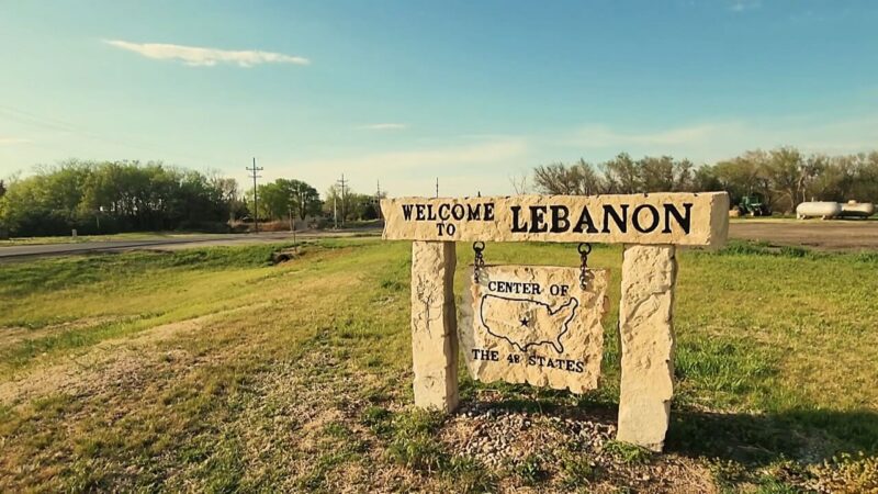
Near Lebanon, Kansas, a small roadside marker commemorates one of the country’s most unique geographic quirks: the center of the contiguous United States. Located a few miles outside town and surrounded by farmland, the site features a stone monument, a flagpole, a picnic shelter, and a small white chapel.
The United States Geological Survey locates the geographic center of the conterminous United States here in Smith County, at approximately 39°50′ N latitude and 98°35′ W longitude. However, the USGS notes that no federal agency has ever officially designated a singular, permanent survey pin as the exact center. The Lebanon monument serves as the recognized public landmark for the calculation rather than a mathematically perfect anchor.
The History Behind the Landmark
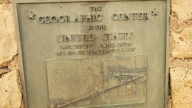
Lebanon’s claim stems from early geodetic calculations of the 48 connected states. The original methodology treated the nation’s footprint as a flat plane of uniform thickness, seeking the exact point where that shape would balance. While practical for the era, this gravity-center method lacks the precision required to pinpoint a single rock or fencepost.
The Kansas Historical Society marker text reflects this legacy, describing the site as the balance point for a flat map of the nation. Unveiled in 1941 through a joint effort by local residents and state organizations, the site has operated as a historic roadside attraction ever since. The official Travel Kansas listing designates it as the Geographic Center of the 48 Contiguous States, highlighting the landmark’s enduring role in American travel culture.
What to Expect at the Site
The landmark sits in rural Smith County, away from any major urban centers. According to the Smith County tourism page, local business owners and professionals financed the stone monument after government surveys identified the coordinates. Their effort transformed a dry geodetic data point into a physical destination.
| Point of Interest | Description | Average Visit Duration |
|---|---|---|
| Geographic Center Monument | The primary stone marker dedicated to the lower 48 states. | 10 to 15 minutes |
| United States Center Chapel | A tiny, eight-pew white chapel open to visitors. | 10 minutes |
| Picnic Shelter | A covered roadside rest area for travelers. | 15 to 30 minutes |
| Town of Lebanon | The nearby rural community anchoring the landmark. | 20 to 45 minutes |
Lebanon remains highly remote. Data from the American Community Survey, published via Census Reporter, places the town’s population at roughly 191 residents. Reaching the site requires driving local highways rather than taking an interstate exit, preserving its status as a deliberate detour for cross-country travelers.
In our historical ranking of all 50 states by population, Kansas consistently ranks as a low-density state, which is evident in the quiet, agrarian landscape surrounding the monument.
48 States vs. the Whole Country
The landmark near Lebanon represents the center of the contiguous 48 states only. When Alaska and Hawaii achieved statehood in 1959, the geographic center of the entire United States shifted approximately 439 miles northwest.
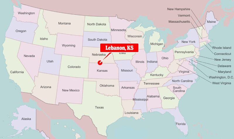
The USGS places the official 50-state geographic center in Butte County, South Dakota, west of Castle Rock. Despite losing its technical status as the national center, Lebanon remains prominent in the American cultural imagination, deeply tied to the iconography of classic coast-to-coast road trips.
Furthermore, the physical monument sits slightly away from the actual mathematical coordinates, which lie on private property nearby. This discrepancy underscores a broader reality of cartography: geographic centers shift depending on changing coastlines, measurement techniques, and map projections.
Road Trip Planning and Logistics
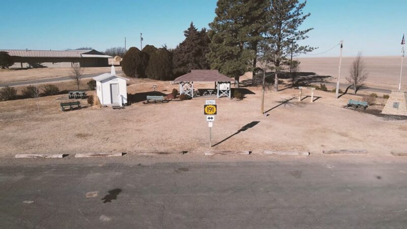
The monument is located near the intersection of K-191 and AA Road. The Historical Marker Database notes the site sits along State Highway 191, roughly one mile west of U.S. Highway 281. The location is easily accessible by car during daylight hours, though travelers should download maps beforehand due to spotty cellular service in rural Smith County.
| Travel Metric | Planning Recommendation |
|---|---|
| Optimal Timing | Daylight hours; morning and late afternoon offer the best visibility. |
| Required Time | 30 to 60 minutes is sufficient to tour the markers and chapel. |
| Road Conditions | Standard two-lane rural highways, easily navigable in clear weather. |
| Best Seasons | Spring and autumn offer mild temperatures. |
| Essential Supplies | Fuel, water, and downloaded offline navigation. |
Summer temperatures in north-central Kansas frequently exceed 90 degrees Fahrenheit with minimal shade at the plaza. Conversely, winter travel introduces risks of ice, drifting snow, and strong prairie winds, making seasonal forecasts essential for safety.
The High Plains Landscape
The attraction offers no major commercial infrastructure, museums, or interactive exhibits. Its appeal relies on historical context and geography. It contextualizes the sheer scale of the American Midwest, matching the themes found in our overview of the smallest cities in the United States, where community identity is defined by isolation and scale.
According to the U.S. Census Bureau QuickFacts, the population of Kansas stood at 2,977,220 as of July 1, 2025, yielding an average density of just 35.9 people per square mile. This open landscape forms the core of the visitor experience.
While the region lacks traditional tourist hubs, travelers can maximize their trip with a few specific stops:
- Photograph the 1941 stone monument and the Hub Hotel marker.
- Visit the interior of the tiny U.S. Center Chapel.
- Drive through downtown Lebanon to see the rural community behind the landmark.
- Utilize nearby Smith Center for dining, fuel, and lodging.
As noted in our assessment of the most beautiful states in the United States, regional aesthetics vary significantly. The High Plains rely on expansive horizons, agricultural geometry, and unobstructed skies rather than dramatic topography.
Frequently Asked Questions
Summary
The geographic center near Lebanon, Kansas, stands as a monument to early American cartography and small-town boosterism. It offers a quiet, uncommercialized look at the exact middle of the lower 48 states, proving that some of the most compelling stops on an American road trip are found on the two-lane highways connecting the coasts.