Throughout Alabama, several magnificent mountains provide breathtaking scenery. Although Alabama does not boast the tallest peaks, it does have numerous mountains that provide breathtaking beauty.
Whether you enjoy hiking or simply lying back and taking in the scenery, you’ll be eager to pack your belongings and travel to these mountains. Let me help you by mentioning the highest mountains in Alabama that you might visit with jaw-dropping scenery.
1. Appalachian Mountains
The Appalachian Mountains, sometimes known as the Appalachians, are a mountain range in eastern to northern North America. During the Ordovician Period, the Appalachians initially developed some 480 million years ago. Elevating 2037 m, this is Alabama’s highest peak.
2. Cheaha Mountain
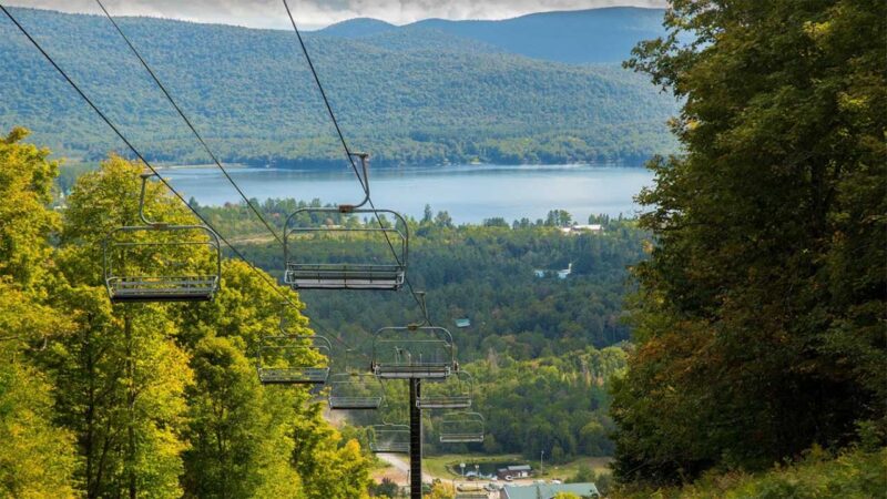
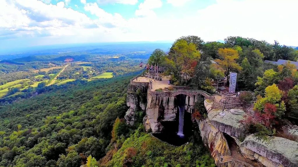
Cheaha Mountain is the highest mountain in Alabama and one of the state’s most popular recreational destinations. Cheaha Mountain and the surrounding region, which is 2,413 feet above sea level in the Talladega National Forest, have a large network of paths that lead to spectacular views and unique campsites.
Highpointers from all over the country come to Alabama’s highest point to check another peak off their list. Cheaha provides “breathtaking scenery and daring recreational activities… a little bit of everything,” according to the Alabama State Parks website.
3. Lookout Mountain
Lookout Mountain is a mountain ridge that may be found in Chattanooga, along the southeastern Tennessee state line, the northwest corner of the U.S. state of Georgia, and the northeast corner of Alabama.
4. Morton Hill
Morton Hill (629 meters above sea level) is one of the Summits in Calhoun County, Alabama, and can be found on the Choccolocco USGS topographic quad map.
With hiking, bicycling, and horse-specific paths, campgrounds, and the variety of scenery made famous in film representations of southeastern states, the national forest provides a picturesque counterpoint to city life, offering tourists a taste of mountain terrain deep in the centre of the South. Then there are the stunning waterfalls that can be found throughout Morton Hill, many of which can be reached via short treks.
5. Oak Mountain

Oak Mountain State Park is Alabama’s biggest state park, with 9,940 acres. It is located on Birmingham’s Double Oak Mountain and provides a variety of activities as well as stunning views.The park was established in 1927 when the State Land Act awarded the park 940 acres (380 hectares) of land between Double Oak Mountain and Little Oak Ridge.
The park was improved by the Civilian Conservation Corps (CCC) and the Works Progress Administration from 1934 to 1941. The golf course, pro shop, cottages, administrative buildings, demonstration farm, and campgrounds were built in the region of Dry Brook basin and near to the park’s lakes beginning in 1971.
Check out these stunning beaches in Alabama.
6. Flagpole Mountain
Flagpole Mountain (474m/1 555ft a.s.l.) is a hill in the United States’ Appalachian Ridges. The prominence is 290 meters (951 feet) high. There is enough untamed outdoors to climb, trek, and explore for nature enthusiasts. There are numerous beautiful state parks within a five-mile radius of Flagpole Mountain.
7. Fox Mountain
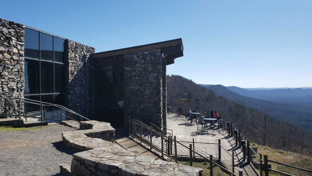
The fifth highest mountain in Alabama is Fox Mountain which is 600 meter tall. It has some of the greatest hiking routes in the area, as well as spectacular mountain panoramas. The mountain also has one of Alabama’s first state parks including numerous CCC-built structures. Hikers and bikers will enjoy Fox Mountain’s trails. Visit the magnificent views while camping at one of the campsites.
8. Oakey Mountain
Oakey Mountain (591m/1 939ft a.s.l.) is a mountain in the United States’ Appalachian Ridges. The elevation is 289m/948ft. Oakey Mountain is a low-lying section of the Appalachian Mountains in east-central Alabama, United States, running northeastward into Cleburne county. It is currently a hotspot for recreational activity, with Cheaha State Park at the apex. It is currently a hotspot for recreational activity, with Cheaha State Park at the apex.
Here are the best fishing lakes in Alabama.
9. Horn Mountain
Horn Mountain (588m/1 929ft a.s.l.) is a mountain in the United States’ Appalachian Ridges. The elevation is 298m/978ft. It is a low-lying portion of the Appalachian Mountains in east-central Alabama that runs northeastward along the Clay-Talladega county line and into Cleburne county.
The eastern part of the Talladega National Forest contains the pine-and-hardwood-covered mountain range that climbs to Cheaha Mountain (2,407 feet [734 meters]), Alabama’s highest point. It’s presently a hub for outdoor leisure, with Cheaha State Park in the epicentre. It’s presently a hub for outdoor leisure, with Cheaha State Park in the epicentre.
10. Weisner Mountain
Weisner Mountain (575m/1 886ft a.s.l.) is a mountain in the United States’ Appalachian Ridges. The prominence is 336 meters (1 102 feet). There is enough untamed outdoors to climb, trek, and explore for nature enthusiasts. There are numerous beautiful state parks within a five-mile radius of Weisner Mountain, so there is plenty of untouched wilderness to be found.
On the border of DeKalb and Cherokee Counties, the Little River Canyon National Preserve is located, and High Falls Park offers hiking and beautiful vistas. DeSoto State Park, just a few minutes away, with 25 miles of a mountain bike and hiking trails, as well as canoeing and kayaking.
11. Burgess Point
Burgess Point, at 571 meters, is the highest point in Alabama. Burgess Point may be found to the north of Erin. The park’s 1,100 acres include grassy slopes, oak woods, and many rivers, all of which provide a home for a variety of animals.
The park now has 6.4 miles of hiking, biking, and horseback riding trails, as well as an 18-hole disc golf course and a natural play area.
As money becomes available, the park’s master plan plans for the construction of 17 miles of trails, hike-in campsites, a visitor centre, and other amenities.
12. Johnson Top
Johnson Top (568 m/1 864 ft a.s.l.) is a peak on the United States’ Cumberland Plateau. The height of the prominence is 224m/735ft. The national forest provides a scenic alternative to city life, providing travellers with a taste of mountain terrain deep in the heart of the South, with hiking, biking, and horse-specific routes, campsites, and the variety of landscape made famous in cinematic depictions of southern states. Then there are the breathtaking waterfalls scattered around Jhonson Top, several of which are accessible via short hikes.
The scenic view of the mountain of the Yellowhammer State is magnificent and welcoming. The state of Alabama is located in the United States Deep South. Alabama’s northern region is one of the state’s most hilly areas. The Appalachian Mountains, which run north from Alabama to the Canadian province of Newfoundland and Labrador, are home to the bulk of the state’s mountains and high peaks.
Check out more about Alabama: